

Click to zoom
StormGeo BonVoyage System 8
The most trusted onboard route optimization and weather monitoring system worldwide
StormGeo gathered feedback from existing customers to develop BVS 8 in line with captains’ needs. StormGeo’s BVS product is used on more than 6000 vessels worldwide. BVS 8 gives clients more tools needed to make the right decisions during a voyage.
“The focus of BVS 8 has been all about improved functionality from a safety and efficiency standpoint, while adding features that make the use of the system easier and more integrated with the bridge,” said Michael O’Brien, StormGeo Shipping VP of Product & Business Development. “BVS 8, through the use of the National Marine Electronics Association (NMEA) standard, allows for position input directly into the BVS track from the GPS. This track file can be shared with shore-side interests allowing for near real-time track and position evaluation. This process automates the position input process ensuring the most accurate dead reckoning of the vessel, providing an improved forecast and more accurate ETA.”
What’s New in BVS 8 from Previous Versions?
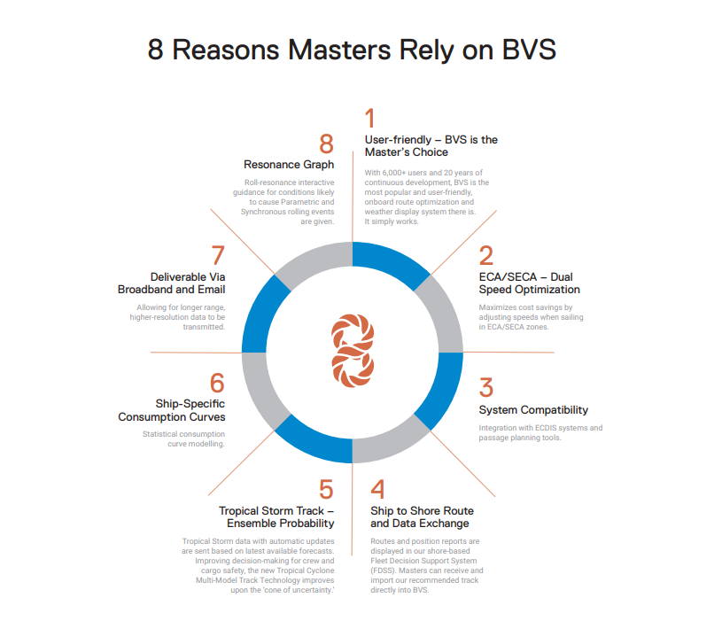
Higher resolution wind and wave data. This data will provide better simulation and optimization results, especially near land. BVS8's HYCOM currents also include tidal effects through a StormGeo post-model process.
Broadband data delivery—system can be set up to deliver the data via ship’s broadband communications links and will fall back to the email solution automatically when broadband communications are not available. Gives user immediate access to more detailed and frequent data updates.
Detailed port vicinity forecasts. Forecasts are 3-days in length and 6-hour time steps. Data includes precipitation amount, temperature, humidity, visibility, and wind conditions. Also provides seas and wind conditions at the pilot station.
Optimization—improved mesh, optimization algorithm, navigation schemes, route smoothing, fuel consumption consideration, etc.
Ship-specific speed down and consumption curves. The speed down curves can be modified by the user. StormGeo has used over 2,500,000 noon reports to evaluate consumption and speed down curves based on ship types. And for those vessels with sufficient reports the curves can be ship specific.
Pirate attack information—BVS displays all attack information reported to the IMB along with corresponding NATO reports.
Rogue wave forecast—72 hour forecast of the areas where a freak wave is more likely to occur due to waves opposing a strong current.